Garmin Nuvi 30C 3.5" GPS Navigator w/ U.S. and Canadian Map Coverage

The Garmin Nuvi GPS Navigation System with U.S. and Canadian Map Coverage provides accurate directions. This Garmin Nuvi GPS Navigator, 30C features a 3.5" touchscreen that provides turn-by-turn navigation that speak street names. With the advanced mapping and navigation technology of the the Garmin GPS Navigator, 3.5" you get fast route calculations and address look-ups. Lane assist with junction view allows you to navigate with confidence while Nuvi directs you to the preferred lane along with viewing images of upcoming junctions. The Garmin Nuvi GPS Navigator, 30C is perfect for an extra car, college student or anyone who could use a little help with directions.


Garmin Nuvi 30C 3.5" GPS Navigator with U.S. and Canadian Map Coverage:
  • Easy to use 3.5" touchscreen
  • Preloaded with City Nav NT for U.S., Canada, Puerto Rico, U.S. Virgin Islands, Cayman Islands and Bahamas
  • Look up addresses for over 6 million points of interest
  • Custom Point of Interest (POI) allows you to add additional points of interest
  • Voice prompts and speaks street names
  • Features lane assist, junction view and route avoidance
  • Built in speed limit indicator helps you keep out of trouble
  • Accepts microSD data card (not included)
  • Rechargeable lithium-ion battery (included)

TomTom START 50M 5" Vehicle GPS with Free Lifetime Map Updates

The TomTom START 50M 5" Vehicle GPS with Free Lifetime Map Updates is here to ensure your journey is smooth from start to finish. It includes our TomTom Maps with IQ Routes and Map Share technology, which keeps you informed with dynamic road changes on a daily basis. Enjoy easy driving with Free Lifetime Map Updates. For the life of your product you can download four or more full map updates on your device every year. You receive updates to the road network, addresses and Points of Interest, to ensure that you always have the industry's most up-to-date map.


Never miss your exit or turn with Advanced Lane Guidance. It shows you exactly which lane to take before you approach an exit, turn or difficult intersection so you can stay on the right path. Choose from over 7 million Points of Interest in over 60 categories and find the nearest restaurants, hotels, shops and more wherever you go.

Navig8r GPS Sports Watch with Google Map tracking

The Navig8r Navwatch S10 is a GPS enabled watch allowing you to track your route for later review and monitor details such as waypoints, latitude / longitude, altitude, dual time zones, stopwatch, date and so on. It even knows where in the world you are so it can synchronise time with the GPS time... imagine stepping off the plane in another country and having accurate to the second time automatically sync up. Great for atheletes, travellers, skiers or adverturers the Navwatch S10 is ruggeed enough to take anwhere. The Navwatch S10 connects to a PC with a USB dock and dedicated software. With the software you can choose to view your route / journey on Google Maps or view waypoint and segment data.
You can also tag photos you may have taken along the way with GPS NMEA data so that others can see on a map where the photo was taken. Simply copy any photo you may have taken with a digital camera, smartphone or even a tablet PC on your journey and the software will match up the time and date of the photo to the time and date of your location which was recorded on the S10 watch. So now you dont need to remember where that great restaurant was or the location of a new picnic spot...take a photo of it, tag it and share it with your friends and family.


Track, monitor and store vital statistics from your adventures or exercise
Add a new dimension to your exercise and sporting experience. Ideal for walking, jogging, biking, hiking and skiing.
Monitor statistics such as coordinates, elevation, speed, trip logs and distance
Bonus PC software suite. Connect, download and share your trip data using Google Maps, Flickr and Picasa.  

Garmin GPSMAP 78s

For boaters and water sports enthusiasts who want to run with the best, the rugged GPSMAP78s features crisp colour mapping, high sensitivity receiver, new moulded rubber side grips, plus a micro SD card slot for loading additional maps. And it floats.
With its high sensitivity WAAS enabled GPS, the GPSMAP 78s locates your position quickly and precisely and maintains its GPS location even in heavy cover and deep canyons. The advantage is clear - whether you are deep in the bush or just near tall buildings and trees, you can count on the 78s to help you find your way out when you need it the most.


Other featurers include a 160H by 240V pixel waterproof screen, 20 hr battery life from 2 AA batteries, 2000 waypoint storage with up to 200 routes, 1.7GB built in memory, electronic compass, barometric altimeter, hunt/fish calendar and tide tables.

DHL 5PCS/LOT TK109 GPS Tracker

TK109, as a personal remote positioning device made up of GPS module and GSM/GPRS module, is compact in dimensions with high accuracy. On the basis of GPS satellites and under dynamic conditions, it can provide you with accurate and correct location information. With such features, it can be used to protect and look for our old people and children. It can also be used for safety purpose and other purposes, such as remote positioning to protect property safety.


Product Features
 1.  Inbuilt GPS Module
 2.  Internet positioning service center, used to receive and send positioning information
 3.  GSM /GPRS modem supports Quad frequency bands, i.e. 850/900/1800/1900 MHz
 4.  High-sensitivity, new workmanship and the most advanced GPS chip
 5.  Can work effectively in limited space such as urban canyon
 6.  Low energy consumption
 7.  Fast signal acquisition
 8.  Supports single positioning and continuous tracking
 9.  Supports alarming and remote monitoring
 10. Supports fast dial button
 11. Supports the location information inquiry by SMS and Internet
 12. May monitor without disturbing the tracked person and realizes real-time tracking
 13. Can position the holder by call or SMS
 14. In emergency, press the SOS button to have an accurate positioning

Garmin eTrex H

With eTrex™ from GARMIN by your side, you can take on the big wide world without looking back. Because when it's time to return to camp or find the dock, eTrex will take you there. This smart handheld is the best of GARMIN GPS in a sleek, water resistant case. Truly a small wonder, the eTrex™ takes the best features of a 12 parallel channel GPS receiver and puts them into a 150 gram package that is only 11.2 cm tall and 5.1 cm wide. The result is a unit that will literally fit in the palm of your hand.


Besides its small size, mariners and bush walkers will likely notice the sleek design of the eTrex. All buttons are located on either side of the unit, allowing for simple, one-handed operation that won't obstruct your view of the display. In fact, the eTrex features only five operator buttons for the ultimate in user-friendly design. Inside the eTrex, you will find the proven performance of a 12 parallel channel GPS receiver that will run for up to 18 hours on just two AA batteries. No need to worry about dense tree canopy with this unit, the eTrex will continue to maintain a tight satellite lock even while operating in forest-like conditions.
The eTrex will store up to 500 user waypoints with graphic icons and boasts GARMIN's exclusive TracBack™ feature that will reverse your track log and help you navigate your way back home. In addition, the eTrex uses animated graphics that will help you identify your marked waypoints quickly and easily.

TOMTOM® URBAN RIDER™3 GPS Device - 3.5" Glove Friendly Touch Screen

Product Features

Rider Pro

Smarter bike navigation at your fingertips
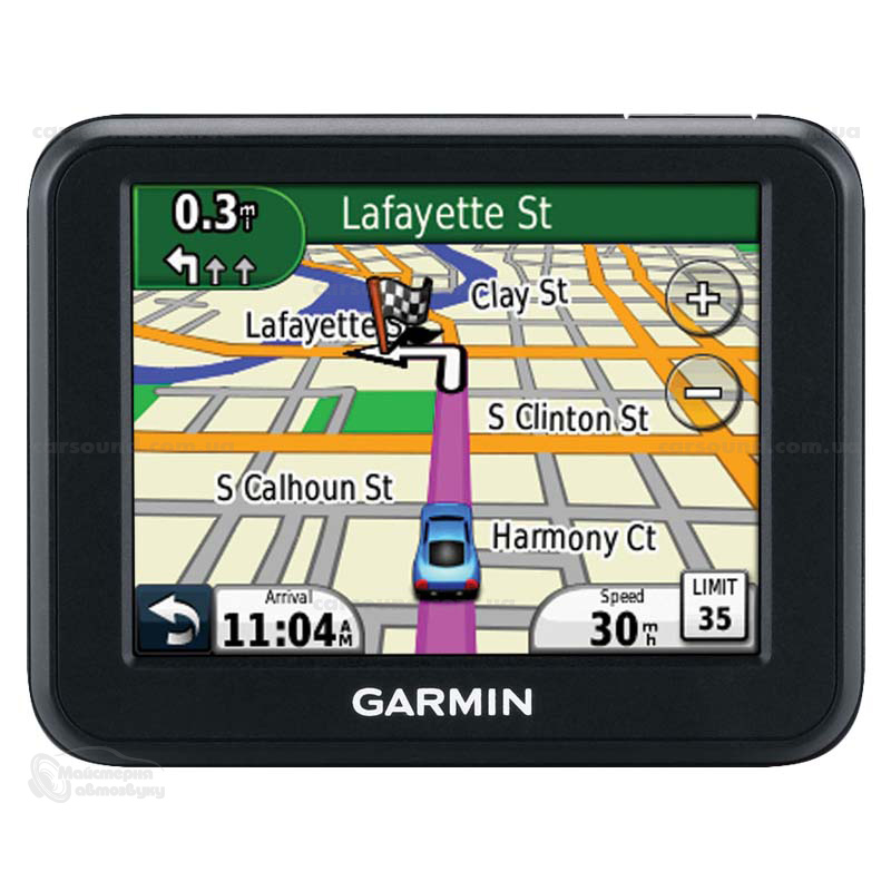
Simplified menu

The main menu has just two simple buttons 'Navigate to' and 'Browse map', so you can get going without any hassle.

3.5" glove-friendly touch screen

Improved glove-friendly screen for easier and safer navigation.


Advanced Lane Guidance

Clearly shows which lane to take at junctions so you don’t miss your turning. On the most difficult highway intersections, realistic 3D representation of the junction keeps you relaxed and safe.

IQ Routes™ technology

Only TomTom uses actual speed data collected from millions of users to calculate the fastest routes at any point in time. Imagine a route that takes into account rush hour, traffic lights, zebra crossings, school exits or even shopping crowds, every minute of every day. That's how smart IQ Routes is!

Simplified menu

The main menu has just two simple buttons 'Navigate to' and 'Browse map', so you can get going without any hassle.

Map Share™ Technology

Make corrections to your own map and benefit from thousands of corrections made by TomTom users every day– free of charge.

Waterproof

Your TomTom RIDER is designed to be as rugged and waterproof as you need it to be, so you can rely on it, whatever the weather.

Advanced Lane Guidance

Clearly shows which lane to take at junctions so you don’t miss your turning. On the most difficult highway intersections, realistic 3D representation of the junction keeps you relaxed and safe.

Latest map guarantee

Start driving with the latest map - guaranteed! If a new map for your device is available within 30 days of first use, you can download that map once for free via TomTom HOME, please note you are only entitled to one free map download. Due to the continuous improvements in our map quality, some new maps may not fit on your device. In these cases, detailed Map Zones are offered for download. You can only use one Map Zone on your device at a time but it's easy and free to change to another zone at any time using TomTom HOME. For more information check www.tomtom.com/mapzones.

TomTom Speed Cameras

Your device comes with fixed speed camera alerts pre-installed, to help you to drive more safely and responsibly, while saving money on speeding fines.

Enhance safety

3.5" glove-friendly touch screen

Improved glove-friendly screen for easier and safer navigation.
Speed-linked volume

Your device is designed to adjust its volume as you adjust your speed, so you can always get your instructions loud & clear.
TÜV tested

TomTom RIDER has passed TÜV safety, quality and durability tests to a level far beyond Euro normal CE standard.

Anti-glare screen and sun visor

Keep the sun off your screen for the optimum view, with the anti-glare screen and built-in sun visor.
Secure RAM mount

Your device is attached to the bike by a mount robust enough to handle tough biking conditions. This mount is made by world-leading mount supplier RAM.
Help Me! emergency menu

You can find help with local emergency service information at your fingertips. From hospitals to roadside assistance, this information will be useful in any area.

Product Specifications


GPS     GPS Receiver     Integrated GPS receiver with 20 Channel all-in-view tracking
Memory
CPU    380 MHz
Memory size    32MB RAM
Screen     Screen size     9cm (3.5 inch), 320 x 240 TFT colour LCD touchscreen
Battery
Battery Life    Internal rechargeable Li-Ion giving approx. 8 hours
Alternative power source    12V motorbike battery
Size & weight
Weight    310 grams
Size    113,2mm x 96,2mm x 52,9mm
Other     Operating Temp.     -10 to 55 degrees C
Other     Waterproof     (IPX7) - protects against any wet-weather conditions
Connectivity     USB     USB port and USB cable 2.0 for PC connection
Mounting     RAM mounting kit     fits nearly all bikes
Compatibility     Helmet compatibility     Supports leading Bluetooth®-enabled helmets

Garmin Echo 100

The Garmin Echo 100  wraps simple operations and Garmin’s exclusive fish finder technology into an entry-level sonar. It’s perfect for any vessel where space is at a premium. It has a waterproof 4" (measured diagonally) screen and operates on a 200 kHz frequency to give a maximum depth of about 180m. The wide viewing angle (60°) lets you see fish even off to the sides of the boat. With an 8 level greyscale screen, the Echo 100 has one of the sharpest screens for the money.


The Fishfinder 90 also offers Ultrascroll™ which allows boaters to get a much faster refresh rate on their sonar display. AutoGain, as well as user adjustable gain, is also standard on all of Garmin’s new fish finders. Audible alarms include fish, shallow water, deep water and low battery. All Garmin Echo fishfinders have 2 years warranty.

China’s Beidou GPS system is as accurate as US GPS system

At  the 2012 Forum of Astronautic Technology and Strategic Emerging Industries in Dalian City, Yang Qiangwen, Chief Engineer of China’s Beidou Satellite Navigation System, said that the system was as accurate as US GPS System. Its horizontal error is less than 10 meters while that high up in sky is less than 15 meters. In measuring speed, its error is less than 0.2 m/s.
China has developed the system over the past 10 years. Its first phase was formally completed in 2003. The three satellites operated satisfactorily. The last satellite for the second phase was launched on October 25 this year to complete a regional network of 16 satellites, in which 14 are providing services in their orbits. The whole system is operating smoothly and is able to provide formal services for the entire Asian-Pacific region.


The third phase, Beidou Global Navigation System will be completed by 2020.
According to estimates, the system is generating 100 billion yuan ($16 billion) revenue now. It is expected that its revenue will rise to 150 billion yuan ($24 billion) and 400 billion yuan ($64 billion) respectively by 2015 and 2020.
Major Chinese producers of the chips have made a breakthrough in the technology related to the chips. They have entered the second and even the third stage of development, and their products are equivalent in technology and functions to those of major companies abroad such as SiRF and uBlox.
Yang said that so far the chips produced by China were expensive and had to be improved through extensive use. He expects that by 2015, China will have its own intellectual property for the chips and the functions of its chips will meet international technical standards then.
He said that Beidou faces cruel international struggle for resources, position and market. There are a limited number of frequencies for navigation systems and the best of them have been taken by the US and Russia. China and Europe who began development of their systems later, have difficulties due to the limited number of channels. The have to conduct negotiation and discussion and do a lot of work to get more and better channels.
Yang also mentioned the possibility of cooperation with the US and Russian systems, but stressed that China had never wavered, and would persist in developing its system independently.
He said that Pakistan and Indonesia are much interested in the Beidou System while Laos, Myanmar, Mongolia and some other countries are also interested. Work is being done to provide the services of the Beidou System abroad.
Source: www.huanqiu.com

TOMTOM® XL™ CLASSIC SA GPS Device - 4.3" Wide Touch Screen

TOMTOM® XL™ CLASSIC SA GPS Device - 4.3" Wide Touch Screen
Large 11cm (4.3”) high quality touch screen.
Touch screen technology gives you the optimum view with the easiest control to make operating your device a pleasure.
6 Preloaded celebrity voices to brighten up your journey: DJ Fresh, Sasha Martinengo, Darren Scott, Mel Miller, Liezel and Beauty.


Helping you to keep your eyes on the road, spoken instructions include street names, to make turnings even clearer.
Make corrections to your own map and benefit from thousands of corrections made by TomTom users every day– free of charge.
Simplified menu for the easiest use.