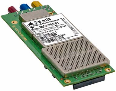
Digi m130 Embedded Module for Cellular, GPS, Satellite Connectivity
Quad-band GSM/GPRS connectivity
ORBCOMM satellite backup data link
Integrated high-performance GPS receiver
Cellular and satellite connectivity provide instant, always-on communications
On-board GPS enables location tracking and geo-fencing
Satellite application-specific integrated circuit (ASIC) technology
Designed for operation in harsh environments
C/C++ programming and Smart Modem mode
5 meters of accuracy virtually anywhere
GPS is getting an $8-billion upgrade
The United States is about to give the now nearly ubiquitous Global Positioning System an $8 billion overhaul. The improvements, which involve replacing each of the 24 aging GPS satellites, are estimated to take over a decade to complete, and will see the triangulation margin of error decrease from 20 feet to around 3 feet. The move comes as more and more devices, from phones to parking meters, are incorporating GPS units into their design. The L.A. Times estimates that there are over 1 billion GPS receivers that rely on the United States’. location system.
GLONASS / GPS integration
Why is this GLONASS / GPS integration such a huge advantage?
In the mid 1990’s the first dual constellation receiver boars appeared on the market that integrated single-frequency GPS plus GLONASS signals. Now we explained that in order to generate coordinates one must be viewing 4 satellites, but to truly generate "Good Coordinates" you would like to see 6 satellites. Finally to have the "best" accuracy you need to receive signals from a minimum of eight satellites. Well, there are times during the day when it is impossible to get eight GPS satellites in view, even on a flat job site! Now, add in some trees, a few buildings—you could be lucky to receive 4 or 5 GPS satellites. What does that do to your accuracy, if you’re able to keep working at all? Ultimately, when you invest in a positioning solution, whether for a surveying crew or for stake less 3-D grading, you want “uptime” not “downtime,” and that uptime must be accurate.
Therefore, the one overwhelming advantage to GPS and GLONASS integral systems is this — the integration provides access to 33 percent more satellites than ordinary GPS. That’s because GPS with GLONASS has the ability to track not only both frequencies of all 24 GPS satellites, it can also receive the signals from the 9 GLONASS positioning satellites (with another 6 GLONASS satellites scheduled for launch this year). The accessibility to more satellites directly relates to the precision obtained. A satellite availability comparison shows that at all times the Dilution of Precisions are lower numbers when GLONASS satellite information is included with GPS satellite positioning information, in comparison to GPS satellite positioning information alone.
AS-19B GPS tracker
AS-19B GPS tracker.
When you open the package it seems that it is very user friendly. You place the SIM card in the GPS Tracker and install the GPS Monitor software on your mobile phone. It seams clear, however you are advised to read the manual first and then follow the directions. In order for GPS Monitor to work you have to activate it and connect it to your mobile phone. It seams simple, however it is essential for it to work properly. You have to send a registration SMS to the GPS Tracker in order to connect it to your mobile phone and number.
Subscribe to:
Comments (Atom)


